
For Educators: Teaching Units & Lesson Plans:
Preparing for the Trip
Lesson Plan 2: The Philadelphia Connection
OBJECTIVES
Students will:
- be able to gather information from a map and be able to identify and describe the geographic location of Philadelphia
- be able to examine and gather information from paintings to identify public and private buildings
- be able to explain the importance of the city of Philadelphia in 1803
MATERIALS
| IMAGES |
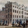
South East Corner of Third and Market Streets, Philadelphia, 1799 View of Several Public Buildings in Philadelphia, 1790 The Long Room, Interior of Front Room in Peale's Museum, 1822 Aaron Arrowsmith, A Map Exhibiting all the New Discoveries in the Interior Parts of North America |
| ACTIVITY SHEET |
Analysis Chart (PDF) |
| SUPPLIES |
Current U.S. map with latitudinal and longitudinal coordinates marked. Small copybooks or paper for each student to be used throughout the unit as a journal. |
OPENING
 Ask students where they would go today to do research for an expedition. What people would they talk with and what places would they go to prepare? Create a list of student ideas.
Explain that in 1803, Philadelphia was the largest city in the United States and the intellectual capital of the country. Until only several years before, it had also been the political capital of the nation. Lewis traveled to Philadelphia in May of 1803 to do research for his expedition.
PROCEDURE
- Divide the class into cooperative groups of four to five per group with a recorder and reporter in each group.
- Distribute the Arrowsmith map from 1803 and the current map to each group.
- Students will locate Philadelphia on each map. Students should describe the relative location of Philadelphia on both maps in terms of relationship to other states, bodies of water, mountain ranges, roads, etc.; record their answers; report to the whole class; and record answers on chart paper.
- Students will find the location of Philadelphia in degrees of longitude and latitude, record their answers, and report to the whole class; teacher will record their answers on chart paper.
Note: Teacher may need to review finding latitude and longitude before applying the skill to this lesson. (Philadelphia is located at 39 degrees North latitude and 75 degrees West longitude.) - Give a copy of one of the paintings and an analysis chart to each group.
- Working together in groups, students will examine a painting, gather information, and record observations on their analysis chart: Who is in the painting? What buildings, activities, and objects can be seen? Where is this taking place? Is it inside a building or outside? (Guide students to be as specific as they can be.) When is this taking place? Why do you think the artist selected this scene? Why is this scene important? (Note: these topics may be revised by the teacher, depending on what can be seen in the paintings. An extra block has been added to the chart to allow for an additional painting, as available.)
- Reporters will share observations with the whole class; teacher will record observations on large-sized analysis chart.
CLOSING
Whole-class guided discussion:
What can you infer about the city of Philadelphia during Meriwether Lewis's visit from the paintings you observed? (large city, busy port, many businesses, public and private buildings, paved streets, streetlights)
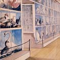 The image of Peale's museum will require some background information. Charles Willson Peale was one of the most remarkable renaissance men of early America. He was first an accomplished artist but also an inventor, naturalist, mastodon excavator, and public educator. Together with his sons, he created a museum that was one of the premier scientific and educational institutions of early America. After 1802, the Peale Museum took over the upstairs rooms of the statehouse where the Declaration of Independence had been signed. It was there when Lewis visited.
Did our city or any cities around us exist in 1803? Most people in 1803 did not live in cities but needed them. What did cities provide to people in rural areas?
SUGGESTED FORMATIVE ASSESSMENT
Journal writing: Tell students that Lewis kept journals while on his expedition. Read a sample journal entry written by Meriwether Lewis. Lewis arrived in Philadelphia on May 7, 1803. Pretend that you are Lewis. Write a journal entry from his point of view describing the location of Philadelphia relative to your home near Charlottesville, Virginia. Describe the direction you had to travel by land from Washington, D.C., and the location of Philadelphia in 1803 in relation to other states, major cities, bodies of water, and mountains.
OR
Write a journal entry about your visit to Philadelphia from Lewis's point of view. Describe what you saw in the city: brick buildings, businesses, people, etc.